Introduction: India’s MLFF Revolution and What Comes Next
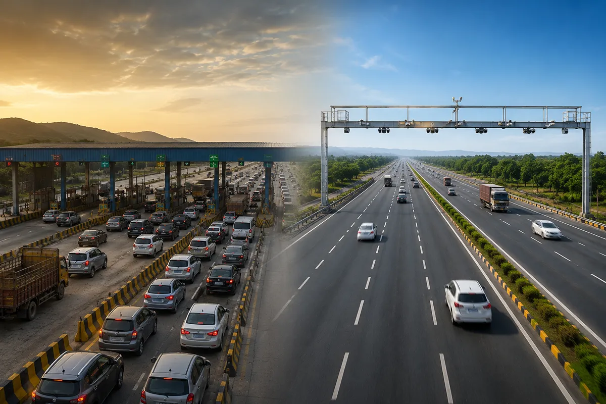
In August 2025, India launched its first Multi-Lane Free Flow (MLFF) tolling system at Choryasi Fee Plaza in Gujarat, marking a transformative moment in highway infrastructure. This barrier-less toll collection system uses RFID readers and ANPR cameras to enable vehicles to pass through toll plazas without stopping, reducing congestion and improving fuel efficiency across India’s National Highway network.
However, as NHAI plans to expand MLFF technology to 25 toll plazas in FY 2025-26, the limitations of current RFID-based systems are becoming apparent. The future of truly seamless MLFF toll collection lies in advanced vehicle detection technologies: 4D speed radars and 2D/3D LiDAR sensors. These next-generation systems deliver unprecedented accuracy in vehicle classification, multi-lane detection, and high-speed free-flow tolling—capabilities essential for India’s ambitious highway modernization goals.
Understanding Current MLFF Technology Limitations
How Today’s MLFF Systems Work
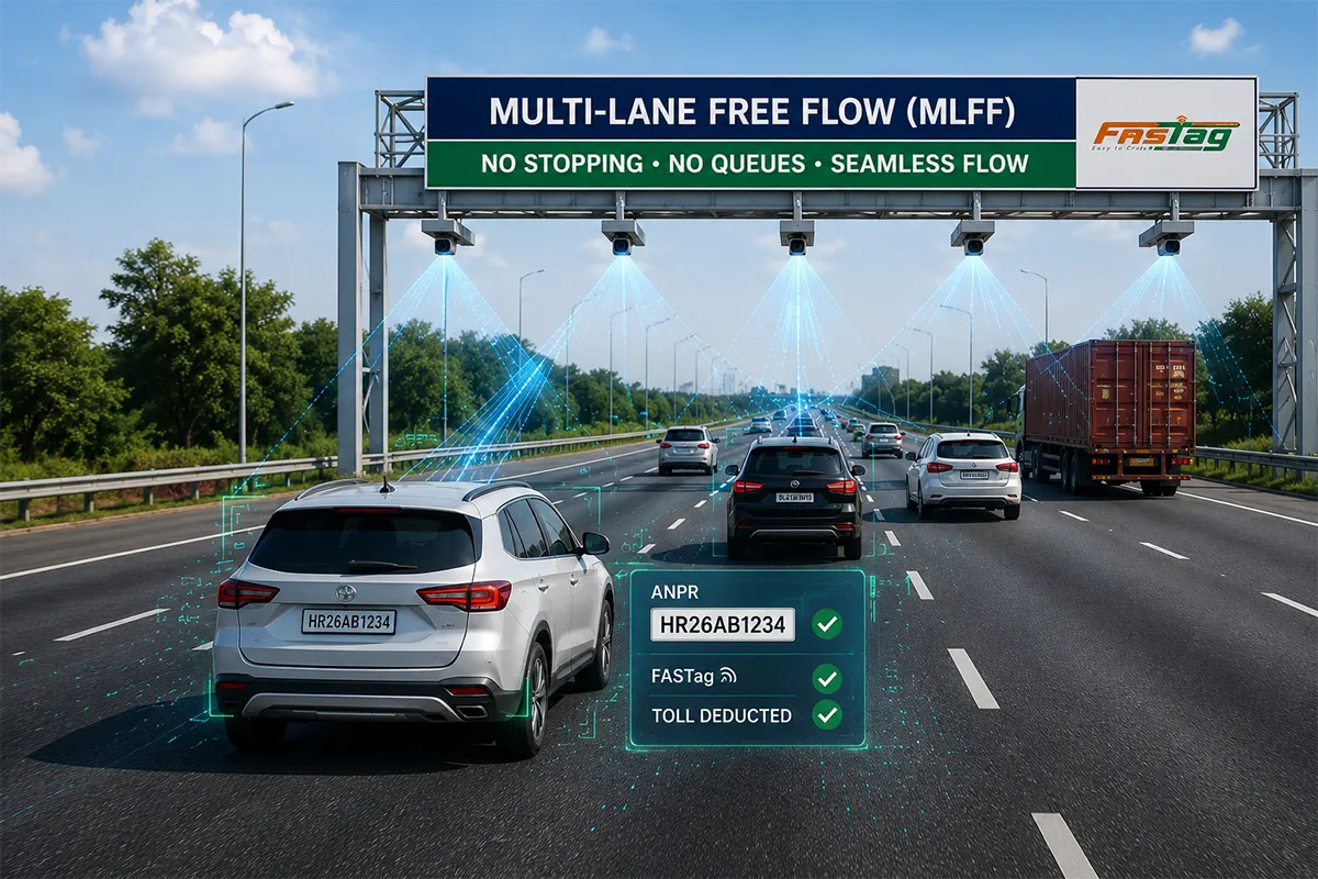
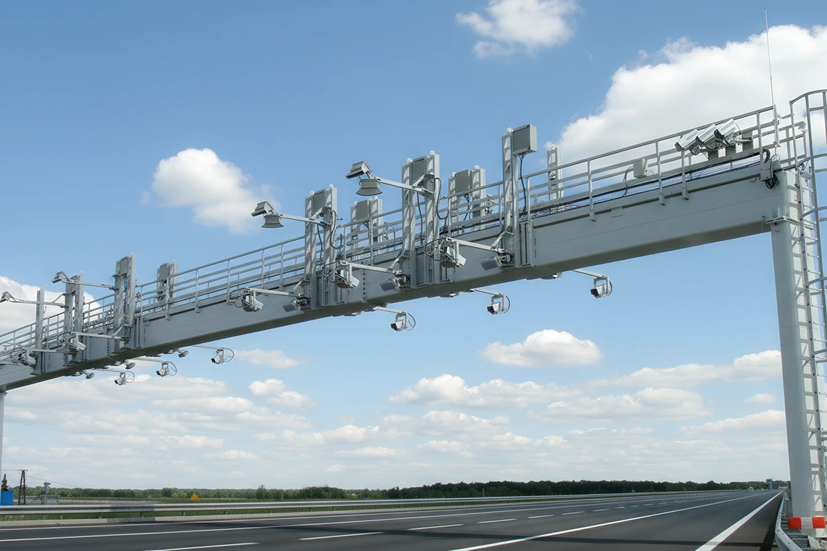
Current MLFF toll collection infrastructure relies on three primary components:
- High-performance RFID readers detecting FASTag transponders
- Front ANPR cameras capturing vehicle registration numbers
- Rear ANPR cameras verifying vehicle identification
While this combination enables barrier-free tolling, several operational challenges persist:
RFID Tag Reading Challenges:
- Tag orientation and mounting position affect read rates
- Multiple vehicles in close proximity cause interference
- Weather conditions impact RFID signal reliability
- Non-FASTag vehicles require fallback to ANPR-only processing
ANPR System Limitations:
- Optical recognition struggles with dirty or damaged license plates
- Night-time and adverse weather conditions reduce accuracy
- Processing time increases during high-traffic periods
- Limited vehicle classification beyond registration data
Multi-Lane Detection Gaps:
- Difficulty distinguishing vehicles traveling side-by-side
- Lane discipline violations complicate transaction assignment
- Vehicle dimension data unavailable for accurate classification
- No real-time validation of axle count for commercial vehicles
These limitations underscore the need for advanced sensor technologies that can deliver comprehensive vehicle detection independent of tags or license plate visibility.
4D Radar Technology: The Foundation of Next-Gen MLFF
What Makes 4D Radar MLFF-Ready?
4D speed radar systems represent a significant evolution beyond traditional 2D radar technology. The RS4D080, for example, delivers true 4D vehicle detection by capturing:
- X, Y, Z Cartesian coordinates for precise spatial positioning
- Azimuth and elevation angles for accurate vehicle tracking
- Velocity measurements exceeding 250 km/h detection capability
- Point cloud data output supporting vehicle classification algorithms
This comprehensive data enables 4D radar to track up to 256 objects simultaneously across 8 bi-directional lanes—a capability far exceeding current MLFF requirements but essential for future scalability.
Key Advantages for MLFF Toll Collection
Multi-Lane Free Flow Capability:
4D radar systems operate effectively across 8 lanes in both directions, maintaining 99.04% accuracy certified by NATRAX (Government of India homologation lab). This enables true free-flow tolling where vehicles maintain highway speeds (up to 250 km/h detection range) without lane-specific restrictions.
All-Weather Reliability:
Unlike optical cameras affected by rain, fog, or darkness, 4D radar delivers consistent performance across all environmental conditions. IP67 weatherproof rating ensures operation in temperatures from -40°C to +75°C—critical for India’s diverse climatic zones from Himalayan highways to tropical coastal corridors.
Vehicle Classification Support:
Point cloud output from 4D radar assists in vehicle classification by providing dimensional data. When integrated with LiDAR sensors and ANPR cameras, this creates a multi-sensor fusion approach delivering classification accuracy exceeding 99% for automatic vehicle class (AVC) determination.
Low Power Consumption:
With power consumption under 4W, 4D radar systems integrate seamlessly with solar-powered toll infrastructure—essential for remote highway locations where grid power availability is limited.
2D LiDAR: Precision Detection for Single and Multi-Lane MLFF
How 2D LiDAR Enhances Toll Collection Accuracy
2D LiDAR sensors utilize Time-of-Flight (ToF) technology with 180° scanning angles to create detailed vehicle profiles. Operating at 50Hz or 100Hz scanning frequencies with 0.25° or 0.5° resolution, these sensors deliver:
- Real-time vehicle count, speed, headway, and occupancy data
- Traffic classification accuracy ≥95% for vehicle type determination
- Speed measurement accuracy ≥95% at up to 120 km/h
- Vehicle dimension detection measuring length, width, and height
MLFF Applications for 2D LiDAR
Free-Flow Toll Plaza Integration:
2D LiDAR sensors mounted on toll gantries detect vehicles as they pass beneath, capturing precise dimensional data for vehicle classification. This enables automatic differentiation between light commercial vehicles (LCVs), heavy commercial vehicles (HCVs), and multi-axle vehicles (MAVs) independent of FASTag or license plate data.
ANPR System Integration:
When deployed alongside ANPR cameras, 2D LiDAR provides dimensional validation ensuring the classified vehicle type matches the registration database. This prevents revenue leakage from misclassified vehicles and supports enforcement against vehicles attempting to use incorrect FASTag categories.
Multi-Lane Detection Capability:
Supporting multi-lane detection with 40-meter range (30m at 10% reflectivity), 2D LiDAR sensors accurately distinguish between vehicles traveling side-by-side in adjacent lanes—a critical capability for assigning toll transactions to correct vehicles in dense traffic conditions.
Weather-Independent Operation:
Unlike camera-based systems degraded by rain, fog, or low light, 2D LiDAR operates effectively 24/7 in all weather conditions. IP68 rating ensures reliable performance during monsoon seasons across India’s highway network.
3D LiDAR: The Ultimate MLFF Solution for Complex Scenarios
Revolutionary 360° Coverage for 4-Lane Detection
3D LiDAR technology represents the pinnacle of vehicle detection capability for MLFF toll collection. With 360° horizontal scanning and 40.5° vertical field of view, a single 3D LiDAR sensor can monitor up to 4 lanes simultaneously—dramatically reducing infrastructure complexity compared to lane-specific sensor deployments.
Key Technical Capabilities:
- 200-meter ranging capability (at 10% reflective surface)
- ±3cm ranging accuracy for precise vehicle measurements
- 5Hz, 10Hz, or 25Hz scanning frequency adaptable to traffic density
- Multi-echo support enabling detection through rain and fog
Advanced Vehicle Classification for MLFF
Axle Count Accuracy:
When paired with one camera per lane, 3D LiDAR achieves 99% axle count accuracy—essential for commercial vehicle toll classification where charges vary by axle configuration. This eliminates disputes over vehicle classification and ensures accurate revenue collection across all vehicle types.
Height Detection for Multi-Level Vehicles:
3D LiDAR accurately detects vehicle height regardless of parallel traffic or close headways—critical for identifying oversized vehicles requiring special toll categories or restricted from certain highway sections.
Complex Scenario Performance:
Unlike 2D systems struggling with cross-lane movements or parallel driving, 3D LiDAR maintains accuracy even in complex traffic scenarios common during peak hours at major toll plazas.
Intelligent Traffic Management Integration
Point Cloud Data Output:
Detailed 3D outlines from point cloud data enable integration with advanced traffic management systems for:
- Real-time traffic flow analysis
- Incident detection and verification
- Queue length measurement
- Wrong-way driving detection
Vehicle Dimension Detection System (VDDS):
Measuring vehicle length, width, and height with ≥99% accuracy, 3D LiDAR prevents oversized vehicles from entering tunnels, underpasses, or restricted sections—enhancing highway safety alongside toll collection functionality.
Multi-Sensor Fusion: Combining Radar and LiDAR for Optimal MLFF
Why Integration Matters for Free-Flow Tolling
The future of MLFF toll collection lies not in single-technology solutions but in multi-sensor fusion architectures combining the strengths of each detection method:
4D Radar + 2D LiDAR + ANPR Camera Integration:
- Radar provides long-range detection and speed measurement
- LiDAR delivers precise vehicle dimensions and classification
- ANPR cameras capture license plates for registration verification
- Combined data achieves >99.5% transaction accuracy
Redundancy and Reliability:
Multi-sensor systems provide operational redundancy—if one sensor experiences temporary degradation (camera lens dirty, radar signal interference), remaining sensors maintain toll collection functionality ensuring revenue continuity.
Enhanced Enforcement Capabilities:
Fusing radar speed data, LiDAR classification, and ANPR identification enables automated enforcement of:
- Over-speeding violations
- Overloaded commercial vehicles
- Wrong vehicle class FASTag usage
- Vehicles attempting toll evasion
Implementation Roadmap: Deploying Next-Gen MLFF in India
Phase 1: Pilot Deployments (2025-2026)
Initial next-gen MLFF implementations should target:
- High-traffic toll plazas where current RFID/ANPR congestion is most problematic
- Multi-lane free flow sections requiring 4+ lane simultaneous monitoring
- Commercial vehicle-heavy corridors where accurate classification significantly impacts revenue
Recommended Configuration:
- One 3D LiDAR sensor per 4-lane section
- 4D radar for long-range detection and speed validation
- ANPR cameras for regulatory compliance and enforcement
- Integration with existing FASTag infrastructure
Phase 2: Corridor-Wide Expansion (2026-2028)
Following successful pilots, expand to complete highway corridors:
- Golden Quadrilateral sections connecting major metros
- North-South and East-West Corridor upgrades
- State highway MLFF implementations following national standards
Phase 3: Nationwide MLFF Standards (2028+)
Establish national standards for next-gen MLFF incorporating:
- Mandatory sensor fusion architectures for new toll plazas
- Backward compatibility with existing FASTag infrastructure
- Data integration with National Highways Authority information systems
- Enforcement integration for automated violation processing
ROI Analysis: Why Next-Gen MLFF Technology Pays Off
Revenue Enhancement
Improved Classification Accuracy:
Upgrading from 95% to 99%+ vehicle classification accuracy reduces revenue leakage significantly. On a toll plaza processing 50,000 commercial vehicles daily at ₹200 average toll, even a 2% accuracy improvement recovers ₹7.3 crore annually.
Reduced Evasion:
Multi-sensor fusion makes toll evasion practically impossible—no single point of failure allows vehicles to pass undetected or misclassified.
Operational Cost Savings
Lower Maintenance Requirements:
Solid-state radar and LiDAR sensors require minimal maintenance compared to camera-based systems requiring regular lens cleaning, housing maintenance, and more frequent replacement.
Reduced Infrastructure Complexity:
Single 3D LiDAR covering 4 lanes reduces sensor deployment, mounting infrastructure, and cabling compared to lane-specific camera arrays.
Energy Efficiency:
Combined power consumption under 50W for complete sensor suite enables solar-powered operation even in remote locations.
User Experience Improvements
True Free-Flow Operation:
Eliminating speed restrictions and lane discipline requirements improves traffic throughput by 30-40% compared to current MLFF implementations, reducing travel time and fuel consumption.
Reduced Disputes:
Higher accuracy reduces customer disputes over vehicle classification, lowering customer service costs and improving user satisfaction.
Choosing the Right Technology for Your MLFF Deployment
When to Deploy 4D Radar
Ideal Applications:
- Long-range vehicle detection (300+ meters)
- High-speed corridors (above 100 km/h average speeds)
- Multi-lane bi-directional monitoring
- Speed enforcement integration requirements
RS4D080 Specifications:
- 8-lane bi-directional capability
- 256 object simultaneous tracking
- 99.04% accuracy (NATRAX certified)
- IP67 weatherproof operation
When to Deploy 2D LiDAR
Ideal Applications:
- Standard toll plazas with moderate traffic
- Single or dual-lane monitoring requirements
- Budget-conscious deployments requiring high accuracy
- Retrofit installations at existing toll infrastructure
Agnibaan 2D LiDAR Specifications:
- 180° scanning angle, 40m range
- 50Hz/100Hz scanning frequency
- IP68 rugged and waterproof
- ≥99% vehicle classification accuracy
When to Deploy 3D LiDAR
Ideal Applications:
- Complex multi-lane scenarios (4+ lanes)
- Commercial vehicle-heavy corridors requiring axle counting
- Urban expressway sections with frequent lane changes
- New-build MLFF infrastructure seeking future-proof technology
Agnibaan Ultra 3D LiDAR Specifications:
- 360° coverage for 4-lane monitoring
- 200m ranging capability
- ≥99% axle count accuracy (with cameras)
- Integrated point cloud processing
Frequently Asked Questions About Next-Gen MLFF Technology
Q: Can 4D radar and LiDAR work alongside existing FASTag infrastructure?
A: Yes, absolutely. Next-gen sensors complement existing RFID readers and ANPR cameras rather than replacing them. This multi-sensor fusion approach provides the highest accuracy while maintaining backward compatibility with current toll collection systems.
Q: What is the typical ROI timeline for deploying 3D LiDAR at toll plazas?
A: Most high-traffic toll plazas (50,000+ daily vehicles) see ROI within 18-24 months through improved classification accuracy, reduced evasion, and lower operational costs. Commercial vehicle-heavy corridors often achieve faster ROI due to higher toll rates and classification complexity.
Q: How do these sensors perform during India’s monsoon season?
A: Both radar and LiDAR sensors maintain operational reliability during heavy rain, unlike camera-based systems. IP67-IP68 weatherproof ratings ensure continuous operation while multi-echo LiDAR processing filters rain interference. Field testing confirms >95% accuracy maintenance even in severe weather.
Q: Are 2D and 3D LiDAR sensors suitable for solar-powered toll installations?
A: Yes, LiDAR power consumption (9-20W typical) makes solar integration feasible. Combined with low-power 4D radar (under 4W), complete sensor suites can operate on solar power with battery backup—essential for remote highway locations.
Conclusion: Building India’s Next-Generation Highway Infrastructure
As India expands MLFF toll collection from pilot deployments to nationwide implementation, the limitations of RFID and camera-only systems will become increasingly apparent. The future belongs to multi-sensor fusion architectures combining 4D radar, 2D/3D LiDAR, and ANPR cameras to deliver:
✅ True free-flow operation at highway speeds without lane restrictions
✅ 99%+ vehicle classification accuracy ensuring revenue optimization
✅ All-weather reliability maintaining operations during monsoons and fog
✅ Scalable architecture supporting 4-8 lane simultaneous monitoring
✅ Future-proof technology adaptable to evolving classification requirements
For highway authorities planning MLFF deployments, investing in next-generation detection technology today prevents costly retrofits tomorrow while delivering immediate improvements in accuracy, throughput, and user experience.
The question is no longer whether advanced sensors will replace RFID-only systems, but how quickly India’s highway network will embrace this technological evolution to achieve truly seamless, barrier-free toll collection.
Ready to Explore Next-Gen MLFF Technology for Your Highway Project?
Rocket Science Technologies offers comprehensive MLFF solutions combining:
- RS4D080 4D Speed Radar for multi-lane vehicle detection
- Agnibaan 2D LiDAR for precision single/multi-lane classification
- Agnibaan Ultra 3D LiDAR for complex 4-lane scenarios
- Integration expertise with existing FASTag and NETC infrastructure
- 24×7 support for mission-critical toll operations
Tags: MLFF tolling, 4D radar technology, LiDAR sensors, free flow toll collection, highway automation India, vehicle detection systems, NHAI toll technology, intelligent transportation systems